Nordegg country
Abraham Lake, Alberta: Ice Bubbles, Seasons, Where to Stay
The turquoise reservoir west of Nordegg, its winter ice bubbles, and how to see it without getting caught out.
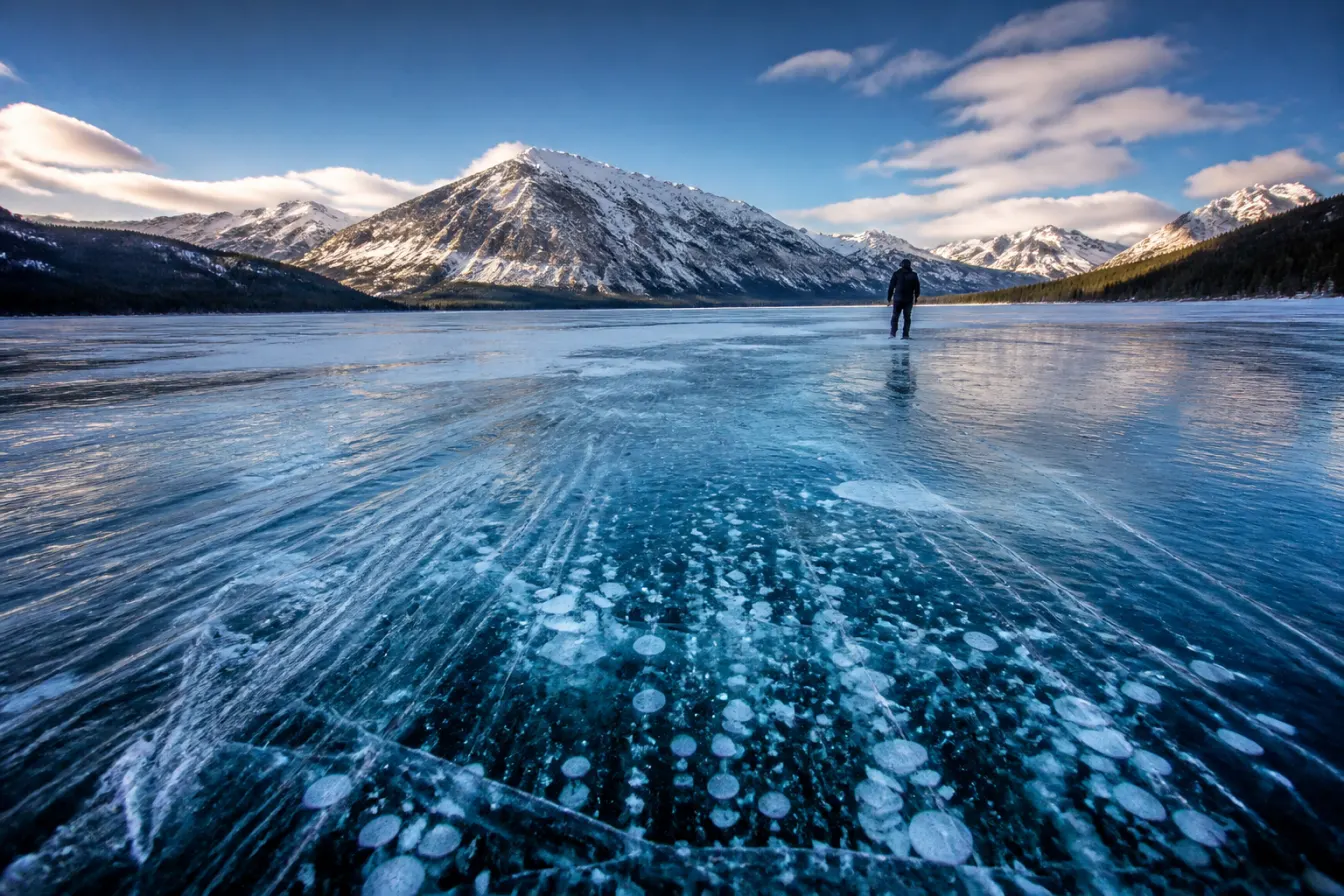
Abraham Lake is a long, turquoise reservoir on the North Saskatchewan River, strung along the David Thompson Highway (Highway 11) in the Alberta foothills west of Nordegg. It is best known for two things. In summer it holds a startling glacial blue that most people only expect to see farther into the mountains, and in the depths of winter its surface famously freezes with columns of white methane bubbles stacked under clear ice. The bubbles are gas rising from plant matter breaking down on the lake bottom, caught and frozen in place as the ice sets. It is real, it is photogenic, and it draws people from all over. This is our backyard. Below is what the lake actually is, when to come, where the roadside views are, and the plain safety truth about walking on any frozen lake, which is that you should treat the ice with a great deal of respect.
What Abraham Lake actually is
Abraham Lake is not a natural lake. It is a reservoir, formed when the Bighorn Dam was built on the North Saskatchewan River, and it is the largest body of water of its kind in this part of the Alberta foothills. That origin explains its shape, a long ribbon of water pinched between ridges, and it explains the colour. The river carries fine glacial sediment, called rock flour, ground out of the mountains upstream. Those particles hang suspended in the water and scatter light back at you, which is what gives the lake its milky turquoise cast on a bright day.
It sits in what we call David Thompson Country, named for the surveyor and mapmaker who worked this stretch of the Rockies two centuries ago. The highway that carries his name runs right alongside the water, so unlike a lot of famous mountain lakes you do not need a long hike to reach it. You can see Abraham Lake from the road, which is a large part of why it has become so well known.
The frozen ice bubbles, explained
The bubbles are the reason a lot of people first hear of the place. Through the warmer months, plant material and other organic matter settle and decompose on the lake bed. That decomposition releases methane gas. The gas rises toward the surface in streams of bubbles, and when the lake freezes hard in the cold months, the ice sets around those rising bubbles and traps them. What you get, when conditions cooperate, is stacks of white discs suspended in clear black ice, tapering down into the depths. Photographers travel a long way for it.
Two honest caveats matter here. First, the effect depends on clear ice with little snow cover, which is not guaranteed on any given day. Wind, snowfall, and warm spells all change what you see, so the striking photos represent good conditions, not every visit. Second, the same gas that makes the spectacle is a reminder that this is a living, moving lake under the ice, and ice over moving water and gas seeps behaves unpredictably. Admire it, photograph it, and read the safety section below before you think about stepping onto it.
When to visit, season by season
The lake is worth seeing in any season, but what you come for changes through the year. Here is the plain version, so you can match your trip to what you actually want.
| Season | What the lake is like |
|---|---|
| Deep winter | The bubble season, when clear hard ice can show the frozen methane columns. Also the coldest and windiest time, so dress for serious cold. |
| Spring | Ice is breaking up and unstable; the lake is in transition. Not the time for the bubbles and not yet the turquoise water. |
| Summer | The turquoise glacial colour is at its best on bright days. The easiest time to travel the highway and pull off at the viewpoints. |
| Fall | Quiet, often dramatic light, and our hunting season in the country beyond the lake. Weather can turn to winter early up here. |
Where to see it from the road
One of the best things about Abraham Lake is how much of it you can take in from the David Thompson Highway. The road runs along the eastern side of the water for much of its length, with pull-offs and rises that open up wide views down the lake toward the peaks. On a clear day the combination of blue water, pale shoreline, and mountains behind is as good as roadside scenery gets in Alberta.
Because it is a reservoir, the shoreline changes with the water level through the year, exposing broad flats of pale rock and gravel when the water is low. Those flats are part of what makes the winter bubble photography so accessible, but they also mean footing and edges shift, so stay aware of where solid ground ends. For the wider drive that takes in the lake along with the other stops in this corridor, see our David Thompson Highway road trip guide.
A plain word on ice and safety
We guide in this country for a living, so we will be straight with you: no frozen lake is ever guaranteed safe, and Abraham Lake in particular is a dammed reservoir with moving water and gas rising through it, which makes its ice less predictable than a still pond. Ice thickness varies enormously across a lake like this, and thin spots, pressure cracks, and open leads can sit close to solid ice. People do walk out onto it in winter, but doing so safely depends on current local knowledge that changes day to day.
So treat the ice with respect. Never assume it is safe because someone else is out on it or because a photo online shows people standing on it. If you want to get out onto the surface, go with a local guide who is reading the conditions that week, tell someone your plans, dress for a fall into cold water even if you never expect one, and be honest about your own experience. You can get a spectacular trip out of Abraham Lake entirely from the shore and the highway, and that is the safe default we would point most visitors toward.
This is the edge of our country
Abraham Lake sits right at the doorstep of the backcountry we hunt. West and south of the water the foothills climb into the Blackstone and Wapiabi country, a zone closed to motorized vehicles where we run horseback, wall-tent hunts the traditional way. Plenty of the hunters who ride out with us pass the lake on the drive in and never forget the sight of it.
If you are planning a hunt with us, this is the country you travel through to reach camp, and it is worth building a little time around. To read what that hunt is actually like, start with our Alberta hunts and David Thompson Country. When you are ready to talk dates, plan your hunt with us and we will walk you through the country from the highway to the high camps.
Common questions
Q. Where is Abraham Lake?
Abraham Lake is a reservoir on the North Saskatchewan River in the Alberta foothills, strung along the David Thompson Highway (Highway 11) west of the hamlet of Nordegg. Because the highway runs right beside it, you can see the lake from the road without a hike.
Q. When can you see the ice bubbles at Abraham Lake?
The frozen methane bubbles appear in the depths of winter, when the lake freezes into clear, hard ice with little snow cover. Because the effect depends on conditions that change with wind, snowfall, and warm spells, the striking photos represent good days rather than every visit.
Q. What causes the bubbles in Abraham Lake?
Plant and organic matter decomposing on the lake bed releases methane gas. The gas rises toward the surface in streams of bubbles, and when the lake freezes hard, the ice sets around them and traps the bubbles as stacks of white discs suspended in clear ice.
Q. Is it safe to walk on Abraham Lake ice?
No frozen lake is ever guaranteed safe, and Abraham Lake is a dammed reservoir with moving water and rising gas, which makes its ice less predictable. Ice thickness varies widely, and thin spots can sit near solid ice. If you want to go onto the surface, go with a local guide reading current conditions, and never assume it is safe because others are out there.
Q. Why is Abraham Lake so blue?
The North Saskatchewan River carries fine glacial sediment, called rock flour, ground out of the mountains upstream. Those particles hang suspended in the water and scatter light, which gives the lake its milky turquoise colour on bright days. The effect is strongest in summer.
Q. What is there to do near Abraham Lake?
The lake anchors a corridor of foothills scenery along the David Thompson Highway, with roadside viewpoints, nearby waterfalls, and the hamlet of Nordegg. It also sits at the edge of the Blackstone and Wapiabi backcountry we hunt on horseback. Check current conditions locally before any winter or backcountry outing.
Keep reading
Plan your hunt
Ask us about a hunt in the country around Abraham Lake
Tell us what you are after. We reply within 1 to 2 business days with honest numbers, real dates and the outfitters we would send our own family to. It costs you nothing.